Last changed 4 August 2021

1983 RASvy

In March-June 1983 the Australian Army conducted Operation Neuration 83 in the central NT.
4 Fd Svy Sqn
OP Neuration
21 Mar – 12 Jun
NT-WA border to Tennant Creek to Qld border
Estb Survey control by MX 1502 Doppler Satellite receiver. Panel and photograph existing survey points for 1:50,000 mapping of primary road communication routes.
OC Capt Peter Jensen (2010:7)
Op NEURATION 83 field annotate 15 x 1:100 000 OPMs from Aileron to Newcastle Waters NT; and control survey for 348 x 1:50 000 in NT Tac Map Area using Magnavox 1502 Geoceiver, panelling and ident photography.
(Demaine 2012:12)
Operation Neuration 83 operated west to Longitude 133°, and at Renner Springs, Barrow Creek, and Avon Downs.

CPL Rod Cark checking the operation of his georeceiver

Officer in command, Captain Peter Jensen with CPL Rod Clarke

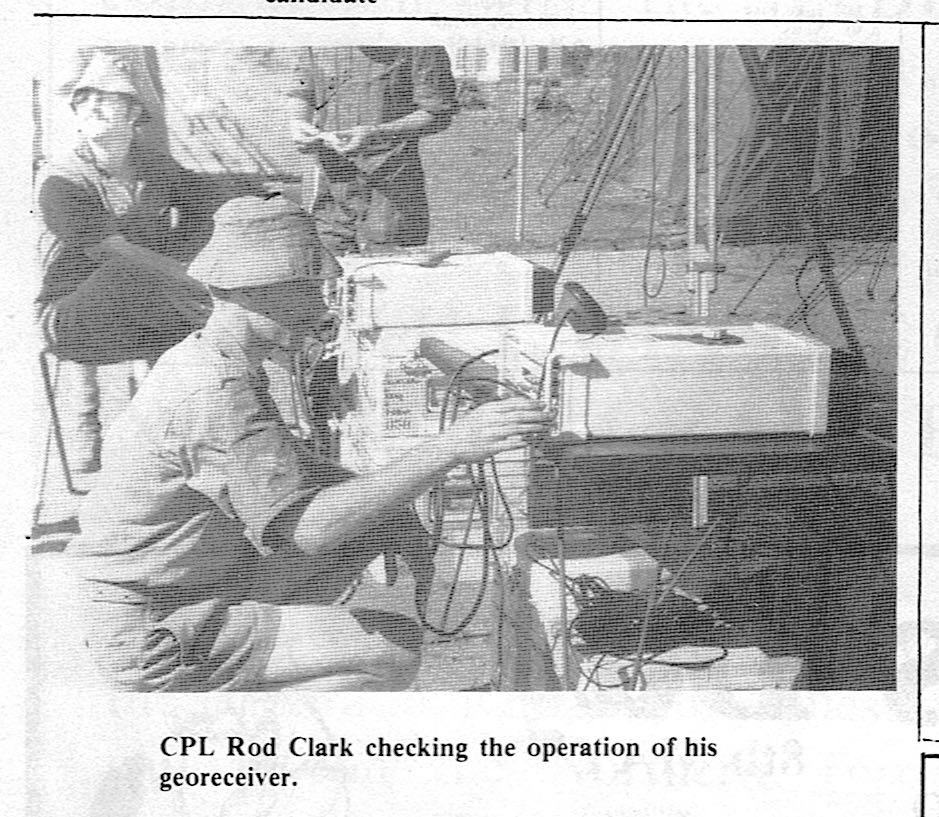
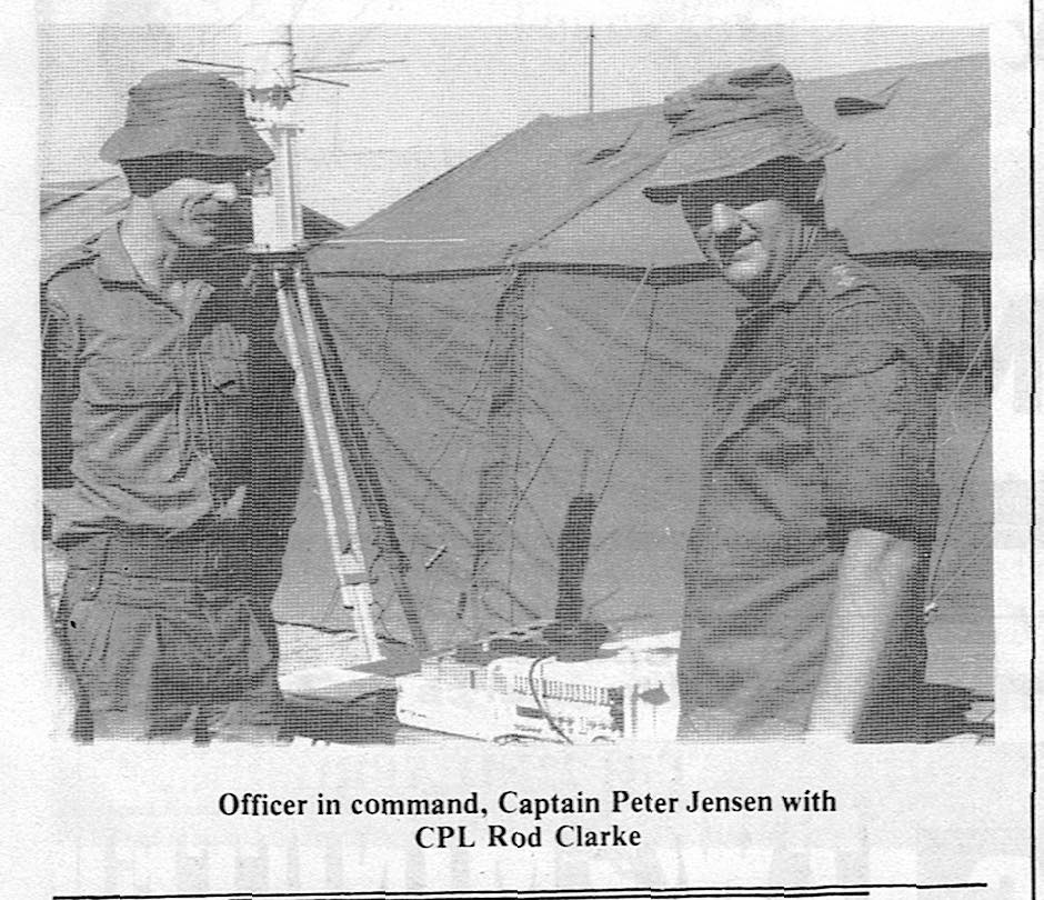
'CPL Rod Cark checking the operation of his georeceiver' (T&DT) 'Officer in command, Captain Peter Jensen with CPL Rod Clarke' (T&DT)

Army mapping territory
'Army mapping territory' Tennant & District Times 4.12 15 April 1983, page 7

Capt Peter Jensen was Officer Commanding (OC) the Army's 1983 Operation Neuration (4 Field Survey Squadron) field survey based in Tennant Creek. Captain (Peter Charles) Warwick was the Technical Warrant Officer.
Operation Neuration 83 (March-June) in Barrow Creek, then based at Outback Caravan Park Tennant Creek, then Avon Downs. Capt (Mark Lawrence) Heinrich was Ops Officer 4 FSS. 4 FSS was from Keswick SA

'A major part of that operation was to establish survey control for scale 1:50,000 military topographic mapping along the major communications routes from QLD to WA and from the SA border to south of Katherine.' (p.c., P. Jensen) The RASvy 4th FSS established stations in the northern Tanami Desert. The major survey method was using US Navy Transit (Doppler satellite) Geodetic Receivers. Access was by helicopter except for U773.

April 1983
U772   Renner Springs 276°M for 86km
U773   by vehicle from Powell Creek homestead for 44.1km
U782   Renner Springs 210°M for 52km

15-17 May 1983
U781   Renner Springs 237°M for 87km
U783   Cattle Creek landing ground 114°M for 110km
U784   Cattle Creek landing ground 96°M for 49km
U785   Camfield Homestead 110°M for 84km
U786   No.11 Bore (Govt), 190°M for 26km
U806   Cattle Creek landing ground 132°M for 65km

July 1985
U881   Cattle Creek landing ground 132°M for 65km


Each station was marked by a RASvy bronze plaque, 9cm in diameter, stamped with the station name, set in a precast concrete block to protrude 5cm above ground level. All but U881 also were beaconed with a 'Witness Post' 6cm diameter GI pipe, capped, painted white, stamped with station name, and sunk to protrude about 1m above ground level.

U772
U772 survey mark, 11:50am 15 July 1993
18°14'30" 132°59'52"
Witness Post 1.83m 00°00'M from station mark

Around each station are three Reference Marks, each a 1cm diameter brass rod set in precast concrete blocks to protrude 5cm above ground level, placed about 5m from the station mark, bearing about 60°M, 180°M and 300°M.

Coordinates

The coordinates of each survey station are available in the interactive map above and are repeated here in DMS format:

U763    19°00'27"N 133°30'04"E

U772    18°14'30" 132°59'52"    April 1983
U773    18°16'35" 133°30'07"    April 1983
U781    18°45'46" 132°59'23"    May 1983

U782    18°42'50" 133°29'35"    April 1983
U782 height 246  -18 -42 -50.42, 133 29 34.547 (-18.714005556,133.492929722 AGD66)

U783    18°00'02" 132°31'21"    May 1983
U784    17°42'11" 132°0'53"    15-17/5/83
U785    17°21'00" 132°01'24"    May 1983
U786    16°59'45" 132°28'07"    May 1983

U806
U881

There is also U763, with similar markings but I have not ascertained the circumstances of its establishment:
U763
U763 survey mark, 4:16pm 18 July 1993
19°00'27"N 133°30'04"E
Note the Reference Mark south of the station mark.

References

'Army mapping territory' Tennant & District Times 4.12 15 April 1983, page 7

Corporal Baylis (Ordnance Corps) and WO1 'Stevo' Hinic (on 7/9/1990)
4th Field Survey Squadron, 4th Military District, Anzac Highway, Keswick SA 5035

Major Mark Heinrich, Survey section, Campbell Park offices (3/3/1992)

Demaine, Peter C. 2012 [written 1995]. 4 Fd Svy Sqn Field Operations & Tasking. Royal Australian Survey Corps Association. ACT Newsletter Issue 3/12, 3-16. http://rasurvey.org/ACTNewsletters/15-12.pdf

Jensen, Peter. 2014. A Nominal Roll of the Royal Australian Survey Corps 1910-1996. Royal Australian Survey Corps Association http://www.rasurvey.org

Email with Peter Jensen, 26/7/2021.

2010. What we did – Svy Units based in SOUTH AUSTRALIA. Royal Australian Survey Corps Association http://www.rasurvey.org

National Mapping Council of Australia. Station Summaries. Copies supplied March 1992 by Bob Twilley, Auslig, Bruce ACT.

Doppler satellite station analysis for station U784. 2 Nov 1983. Photocopy of computer printout.

Geosciences Australia National Geospatial Reference System


Karlantijpa history page
Karlantijpa home page
© 2021 David Nash
Created 21 July 2021
Last changed 4 August 2021
URL http://www.anu.edu.au/linguistics/nash/kt/1983-RASvy.html