|
|
 |
| 1986 | 2016 |
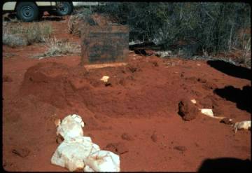
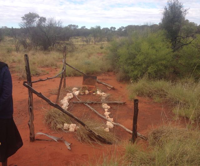
There are white quartz stones in a rectangle marking the grave itself. The lettering professionally engraved in the metal marker at the head of the grave reads:
On the south side of a hill of dark rock is a mineshaft, rectangular in cross-section, timbered a bit at the top, and perhaps 5m deep. There is a graded track to here — an arc which meets the Lander at Jangankurlangu (Boomerang Hole) and north of Austerity Well.
About a mile northwest of the mine shaft and off the graded track there
is an isolated grave. One could go by 10m away and not notice it in the
scrub.
|
|
|
| 1986 | 2016 |
There are white quartz stones in a rectangle marking the grave itself. The lettering professionally engraved in the metal marker at the head of the grave reads:
IN MEMORIAM
Harold Alfred Waldron who died here Sunday 3rd October, 1937.
Aged 61 years.
TO STRIVE, TO SEEK, TO FIND AND NOT TO YIELD.1
A small metal cross which had become detached from the top of the plate
was replaced by one of the Warlpiri men (1986). An antbed had grown up as if it
were a head stone, and completely enveloped the marker. In mid-1986 the
late Martin Jampijinpa of Willowra had maintained the grave by knocking
away the upper part of the mound to expose the marker.
It is about 10km south to Jangankurlangu, known in Warlpiri history as the place where the trouble started (the 1928 killings). It was the miners' largest source of water, and on occasion the workers would go there to wash clothes and so on. On the Sunday of Waldron's death, the workers were told (by Waldron?) to take the cart and have the day off at Boomerang Hole, and that they should take their lunch, and not worry about hurrying back. Waldron was known as a good old man. People of various Aboriginal and European ancestry were living and working at his prospect, and his plans for their day were quite normal.
With everyone else gone, an argument developed between Waldron and a white man working there. What went on is something of a mystery. Jack Simpson ("The Brindled Stag") and Doug Cooper, a pair of itinerant prospectors who travelled areas to the north-east, worked at the prospect, and were somehow involved. According to Walter Smith (Kimber 1986:115), Simpson and Cooper "latched on to" Waldron who claimed to be a gold-diviner and led them to his prospect. There is a suggestion that Waldron had a chest of valuable ore or perhaps gold, perhaps even still buried in the area. According to Walter Smith, the dispute came when the promise of good gold did not eventuate. In any case, the argument led to the other man killing Waldron with a blow to his head.
Since there were no witnesses, the man who had killed Waldron decided to make out that the death had been accidental. He loaded the body onto a mule and part-dragged it around and around in the scrub, to make out that Waldron had fallen from his mount and been caught and dragged by a stirrup. When the workers returned at last light, they were greeted with this account. How word travelled somehow to the authorities. In Walter Smith's account, the two white men reported the death in Tennant Creek, and "the police accepted the story that the gold-diviner's head had been battered when, in falling from a camel, he caught his foot in a stirrup and was dragged at a gallop across the country."
An aeroplane carrying a doctor and a policeman landed on the clear gravel patch north of the mine, and began an inquiry into the death. At some stage the Aboriginal people, at least, suspected the story of the horse (or camel or mule) accident. For instance, they knew the animals Waldron had were quiet ones. Although the alleged killer was never charged, the Warlpiri version of the events was widely believed.
Some of Waldron's family have come to the grave, and were responsible
for the erection of the marker.
Sydney University’s Calendar announces the annual Harold Alfred Waldron
Memorial Prize in Bacteriology was "founded in 1938 by a gift from Mrs
H Markham and Mr F D’Arcy Williams". Mr D’Arcy Williams was a nephew; Waldron
had a son Harold Francis Hunt (born Strathfield 1924, d.1970).
According to the standard geological reference,
Waldrons Hill gold prospect consists of a gold-bearing carbonate-veined quartz vein filling a shear zone. The country rock consists of amphibolitised dolerite and medium-grained biotite granite surrounded by garnet-sillimanite-cordierite hornfels.The source reference (Hossfield 1941) reads as follows:
Samples collected by the Aerial Geological and Geophysical Survey of Northern Australia from the mine dump contained 5 g/tonne of gold (Anonymous, 1941). A sample of the carbonate-veined quartz collected during this survey contained 0.4 g/tonne of gold (see Table 2). (Kennewell & Offe 1979:14)
14. Waldron's HillInterest was shown in the area in the early 1970's. Exploration Licence 115 was granted to B.D. Brown on 18 October 1970 (CR 73/178), and to G.S. Rhea on 16 May 1973. A report from that period states:
This hill is situated about 76 miles north of Peake station, and approximately 120 miles to the west of Wauchope Well. It is stated to be 6 miles east of the Boomerang Water Hole in the lower Lander River. From the top of the hill no surface relief is visible except possibly the tip of Mount Leichhardt to the south.
Waldron's Hill is composed of igneous rock, chiefly basic in character, but including probably some quartz-diorites. Acid pegmatites occur, and a porphyritic rock of acid character outcrops near the eastern end of the hill. The hill run approximately east and west. At the western end of the hill a costean bearing at 196 degrees has been dug, and to the west of that a shallow shaft put down. This costean has a length of 237 feet, an average depth of 6 feet, and an average width of 3 feet. The shaft was inaccessible. The material excavated from the costean shows a large amount of surface tufa, probably a decomposition product of the basic igneous rock. Eight samples were taken along this costean and returned traces of gold only, except for one sample which returned 0.9 dwt. of gold per ton. Samples taken of the material from the dump at the shaft returned 3.75 dwt. of gold per ton. The dump material from the shaft appeared to consist of decomposed slate with a little quartz, and some limonite encrustations. The amount of such slaty material, however, appears to be very small, and no prospects are held out for the discovery of payable deposits of a workable size.
Between Waldron's Hill and the Lander River to the south-west, there occur over a distance of 6 miles, a number of areas containing detrital quartz of angular appearance, and therefore close to the source from which it is derived. The occurrence of such areas which f[...] no elevations above the surrounding level of the spinnifex plain, suggest the possibility that the rocks from which these are derived, although buried by sand or soil, may be close to the surface, and also that since the area is known to be auriferous, gold deposits may be located although their existence is marked only by detrital material.
In this enormous area of practically level country (of which the part examined forms only a fraction), and also in the area between it and The Granites, actual elevations above the surface, and outcrops, are few, but the probable existence just beneath the surface of quartz reefs, as indicated by the detrital material found here and also under similar conditions in The Granites district, suggest the possibility that the search for auriferous deposits should not be confined merely to the few hills existing in the area.
On 9 September 1986, Yuendumu Mining Company N.L. applied for an Exploration Licence (No. 5136) over an area of 26 blocks (about 84 km2) which included Waldron's Hill.
29.6.11 Left camp at 9 a.m. travelled north all day to night camp — distant 24 miles. The first 2 miles the country is similar to that described on 15th inst. then it rises gradually to spinnifex plain lightly timbered with Bloodwood (120), Hakea, Sandalwood, Acacia 236, Eucalyptus 392. At about 8 miles there is a belt of Mulga and Acacia (373) on good soil carrying a fair quantity of herbiage (chiefly 38). At this point there is an outcrop of rock & about 2 miles to the east there is a low sandstone ridge with a heavy quartz reef on N.E. face. I rode over to this ridge and examined the reef.2The continuation of that expedition from Borroloola to Alice Springs had as MacPherson's second-in-command a cadet surveyor Mr John J. Waldron, whose connexion with this Waldron is unknown.After passing this Mulga and Acacia (373) country, the soil becomes very sandy. After passing through a dense belt of Acacia 358, sandhill country is entered and the flora changes considerably. [...botanical details...]
At about 12 miles from the morning camp 2 natives were seen. Both wore coverings over penis but had no other articles of dress or ornaments. Both carried stone knives, shields, womeras & spears (with wooden points and no barbs). I was riding at some distance behind the party when these natives caught up to me. They indicated by signs that there was water in several places to the westward. They were both very nervous and excited. I took a shoemakers knife from my bag and offered it in exchange for a stone knife but they evidently mistook my intention and after backing away and talking excitedly, took to their heels. I tried to get them to come back but they continued for [new page] about 200 yards where they found several others and all ran off into the scrub. The two who had come up to me were both of small stature but were in excellent condition. Before they ran away they indicated by signs that their lubras were behind some scrub about a couple of hundreds yds. away and that they would bring them up. Thinking of the proverb 'A Bird in the hand, etc.', I wished to get a stone knife first and it was my attempt to make an exchange that brought the interview to a sudden end. Many native tracks and fires were seen near here.
This place was not visited in the course of the Willowra land claim, or the nearby Kaytej-Warlpiri land claim, although Anatoly Sawenko (in 1981) had it pointed out to him from a hill further east and was told something of the story of Waldron's death. The claim material has nothing of the events recounted above.
I have been unsuccessful in attempts to contact the relatives of Waldron
who have tended the grave.
Waldron family tree information is at http://www.merchantnetworks.com.au/genealogy/web/waldron/pafg09.htm including HA Waldron.
SMH Wed 13 Oct 1937, 16 - Family Notices http://trove.nla.gov.au/newspaper/article/17416127
Driven through the desert by a spirit. Even in a Land of Queer People, 'Professor' Waldron was Eccentric.
The Argus (Melbourne) 28 May 1938, 2 (The Argus Week-end Magazine) http://trove.nla.gov.au/newspaper/article/11171121
published refereces:
[Hossfeld, P.S.] 1941. Waldron's Hill. Section 14. Aer. geol. geophys.
Surv. N. Aust., Ann. Rep. to 31st December 1940, 58-59.
[This citation replaces that given by Kennewell & Offe 1979 as
Anonymous. 1941. Delny wolfram discovery. Aer. geol. geophys. Surv.
N. Aust., Ann. Rep. to 31st December 1940, 56.
which is irrelevant.]
Kimber, R.G. 1986. The Man from Arltunga. Walter Smith. Australian Bushman. Carlisle, W.A.: Hesperian Press. ISBN 0 85905 084 X $24.50
Kennewell, P.J. & L.A. Offe. 1979. Lander River. Northern Territory. 1:250 000 Geological Series—Explanatory Notes. Canberra: Australian Government Publishing Service.
A.L. Rossiter. 1917. "Northern Territory. Showing Route of Barclay Expedition and Characteristic Vegetation." 1914 map endpaper foldout in The Flora of the Northern Territory, by Alfred J. Ewart & Olive B. Davies. Melbourne: Department of Home and Territories.
20 July 1986
Revised 10 September 1986, 10 May 1987, 4 June 1987, 9 December 1992,
4 November 2001, 26 October 2003.
Created 4 November 2001
Modifed 26 October 2003, 25 May 2016, 14 August 2016
URL http://www.anu.edu.au/linguistics/nash/kt/waldron.html