Davidson, D.
Sutherland. 1938. An ethnic map of Australia. Proceedings of the American Philosophical
Society 79.4, 649-679
For use in conjunction with:
Davidson, D.
Sutherland. 1938. A
preliminary register of Australian
tribes and hordes. Philadelphia, Pa. : American Philosophical
Society.
vi+130 leaves. 1996 microfilm (copy of NLA volume) at AIATSIS Library,
call number MF 224 * introduction
(1.2MB PDF) * sample page 104
(712kB GIF)
Davidson's papers at the Burke Museum, Seattle, includes a copy of his
1938 map with handwritten additions in the eastern Pilbara. Copied
(1980) on fiche 10 of 'Australia collection' at AIATSIS Library, call number
MFE 170.
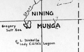
Donald Thomson's map in the 1958 Australian Encyclopaedia
(reproduced on page 2 of the 2005 Macquarie Atlas of Indigenous Australia)
corresponds in large measure to Davidson's 1938 map and does not cite
it; Thomson's
map has the unique 'Mungya' near Lake Gregory (north-east WA) where
Davidson's map has Munga (of RH Mathews 1900:4981)
superposed on a Y-shaped creek
1. per Davidson's Register p.114:
Mathews, Robert Hamilton. 1900. The Wombya organization of the
Australian Aborigines. American
Anthropologist 2,494-501. * p.498 lists various groups, keyed to
a location map. No.9 is '...Meening, Jarroo, and Munga
tribes...', with Munga placed on lower Sturt Creek and Lake Gregory

 Davidson, D.
Sutherland. 1938. An ethnic map of Australia. Proceedings of the American Philosophical
Society 79.4, 649-679
Davidson, D.
Sutherland. 1938. An ethnic map of Australia. Proceedings of the American Philosophical
Society 79.4, 649-679 Davidson, D.
Sutherland. 1938. A
preliminary register of Australian
tribes and hordes. Philadelphia, Pa. : American Philosophical
Society.
vi+130 leaves. 1996 microfilm (copy of NLA volume) at AIATSIS Library,
call number MF 224 * introduction
(1.2MB PDF) * sample page 104
(712kB GIF)
Davidson, D.
Sutherland. 1938. A
preliminary register of Australian
tribes and hordes. Philadelphia, Pa. : American Philosophical
Society.
vi+130 leaves. 1996 microfilm (copy of NLA volume) at AIATSIS Library,
call number MF 224 * introduction
(1.2MB PDF) * sample page 104
(712kB GIF)