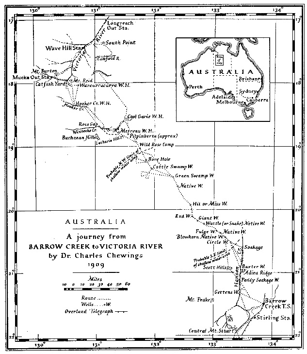
(click on map for larger view)
Paddy was rather good a making "mud maps." These are drawn on the ground with a stick, and are the black fellow's way of showing where and how physical features of interest to him are situated in relation to one another. When requested to show what lay beyond, Paddy drew a map showing the course of the Hanson Creek (the native name is Ahgwaanga), also of the large Lander Creek (native name Allallinga) a good many miles to the west. He indicated certain conspicuous hills near the Lander and the sites of certain springs and soakages one the routes he had travelled, and, by marking his various camps, the time it took to travel from water to water. The production of this map of course took much prompting and questioning. I made of sketch(*) of it which I found useful later on. (*) Not extant (Chewings 1930a:319-20)back at Barrow Creek by 16/8/1909
Hanson soakage well. 5' x 3' (I omitted to measure the depth but) about 9' or 10' deep. The supply is equal to watering about 30 horses daily. The well is well timbered from top to bottom with mulga. (Chewings 1909b)
The Hanson Creek here has a wide bed of deep sand, and looked promising for a soakage that would last some time, so I decided to timber the well and make it a water the we could fall back on in case of need. As Paddy had pointed out the site it will be referred to hereafter as "Paddy's Soakage Well." A sea of mulga scrub on level ground surrounds the well for many miles, and no hills or landmarks of any kind are visible from it. (Chewings 1930a:319)
After we had replenished our food supplies at Barrow Creek we sank two wells (Baxter and Gettens wells) on the Hanson Creek, the positions of which may be seen on the map. (Chewings 1930a:336)
Depth abt 8ft, in sandstone rock. Water rises 2'7" from bottom, Size of well 5' x 3'. makes at the rate of 1296 gals in 24 hours (Chewings 1909b)
At the summit we noted in the distance a low-lying circular hollow a little to the right of our course, and Paddy immediately suggested altering our course to it. … and the natives led us to the first spring, which was in the centre of the hollow. The so-called spring was an oblong hole sunk through the travertine limestone crust into the horizontally disposed sandstone below. The hole was sunk on the incline for 5 or 6 feet, and at the bottom there were about 5 gallons of water. Upon bailing it out we found that the water rose again to the same level, but without a lot of work we saw no prospect of watering twenty camels from it, so we camped and decided to go on to the next spring next morning. [19 April 1909]
… on the return journey we sank a well close to the spring (Chewings 1930a:321)
32 miles from Baxter's on a bearing of 23 West of North through desert country. This well is 8 feet in depth 5'0" X 3'0" through red sandstone capped with a very hard crust of limestone. Estimate water supply about 1,200 gallons in 24 hours. Water fresh. Country around bad, no grass or eatable bush of any kind; the well is situated in Teatree and salt marsh swamp. (Ross 1910)
5'6" deep, size 5' x 3', water rises to within abt 2ft of surface. There is a borehole 20ft deep from surface in this well, up through which most of the water flows, & the yield in 24 hours is 1152 gals. (Chewings 1909b)
At 8 miles from camp we came on another titree swamp with a rather large native well in it, at which camped, with poison-bush all around. On the return journey we sank a well here, getting plenty of good water, and it now bears the name of Fulge Well. This apparently was No 3 spring, but as a matter of fact all the hollows we had passed, and others for many miles yet to come, appeared to have water in them, very near the surface. (Chewings 1930a:322)
20 miles from Circle Well, bearing 22 North of West 8'feet deep, giving over 2,000 gallons of excellent quality water in 24 hours. Country around nothing but desert and no grass, and between these wells is a belt of the deadly Gastrolobium about 16 miles between. (Ross 1910)
Chewings does not explain the origin of the name, but it must be from the geographical term fulje 'interdune basin', a word which has apparently also been used in German, and is derived from Arabic.
Next day, April 23, after watering the camels, we started for Paddy's "big spring." … The water was only a couple of feet from the surface, perfectly fresh, and the supply inexhaustible, as we found when making the native well into a proper well at a later date. (Chewings 1930a:323)
in sandstone rock, depth 5ft, size 5' x 3', water rises 3' from bottom, yields far over 1,000 gals in 24 hours, probably twice or three times that amount, if deepened a foot or two a sea of water will flow in (Chewings 1909b)23 miles from Fulge Well. 9 feet deep through limestone crust. Unlimited supply of fresh water. Country around teatree swamp and other stunted timber, but very little grass. (Ross 1910)
On the 25th we started for the last spring that Paddy had seen. … It is now known as End Well. …(no mention by Ross 1910)
End Well being the end of everything so far as Paddy's knowledge went, … (Chewings 1930a:324)
in sandstone rock. Yield similar to Giant Well, & the same description will answer for this well.
… a hollow surrounded by blowing sandhills, the floor of which was a crust of travertine limestone, or perhaps more correctly, calcareous sandstone, through which was a hole several feet long and 5 or 6 feet wide. The native well was sunk in sandstone below this crust for 3 or 4 feet to water. I calculated the distance from End Well straight to this water-hole at 14 miles, but the route the natives had brought us was very circuitous. … It was a desolate spot, and the well is named the Hit or Miss Well. (Chewings 1930a:324) [27-30 April 1909]
Hit or Miss Well. Is also in sandstone rock, is 12 feet deep has a rocky cave mouth, which is about 4'0" deep. I have not yet timbered the mouth of this well pending your decision as to have the wells cut down to standard size viz., size 6'0" x 4'0", to do so would mean filling the cavern up around 5'0" X 3'0" timber then taking it out and filling it in again around 6'0" x 4'0". As the well has a hard rocky mouth, and is as convenient as any of the other wells to get water from I ventured to leave it against receipt of word from you. The well makes at rate of 1,440 gallons in per 24 hours, and the water rises to within 4'6" of the surface. There is a borehole two feet deep in the bottom, up through [which] much of the water flows (Chewings 1909b)
22 miles from Giant well. 8 feet deep through limestone. Water fresh. Country around the same, nothing but spinifex and low stunted scrub, Supply about 5,000 gallons. (Ross 1910)
There is a green swamp with samphire and other camel feed surrounding a red sandhill a short distance from the well, and from this delectable spot the well derived its name. (Chewings 1930a:325) [2-6 and 11-14 May 1909]
Green Swamp Well. In sandstone rock, depth 6'0", size 5'0" X 3'0" makes at rate of 1,728 gallons in twenty four hours. (Chewings 1909b)
35 miles from Hit or Miss Well. Country between and around this well slightly better, more eatable bush and a littlegrass in places of the course [sic] wirey kind. Depth 8'0". 5'0" X 3'0+ supply 2,000 gallons in 24 hours. This well is situated in the centre of a large Teatree Swamp and the water is of excellent quality. (Ross 1910)
We got a surprise at 3 1/2, and again at 4 1/2 miles from Pigeon Camp at seeing the tracks of one bullock. At the latter distance we dropped on to a plain; at 5 1/2 miles we were again on the top of a high sandhill from which we saw a titree swamp a mile and a half to the north. We went to it, decided to bore, and at 9 feet 6 inches from surface struck a fair supply of fresh water. We then started a well and got down 2 feet on this day also. … The well is named Cattle Swamp Well. (Chewings 1930a:327)
abt 7'6" or 8' deep, water rises to within 3'6" of surface, from a bore hole, 3'6" 15' deep from surface, nearly all the water flows [through?] borehole being in the centre of the well. - makes at the rate of 1080 gals per 24 hours, size of well 5' x 3'. (Chewings 1909b)
24 miles from Green Swamp depth 8 feet 5'0" X 3'0" through sand and rubble limestone. By baling the supply was over 2,000 gallons in 24 hours of fresh water. Country around all desert and nothing for cattle or horses to eat. (Ross 1910)
"Hit or Miss" Well. 22 miles from Giant Well. 8 feet deep through limestone. Water fresh. Country around the same, nothing but spinifex and low stunted scrub, Supply about 5,000 gallons.Chewings apparently accompanied Ross's inspection, as witness his reminiscence:
"Green Swamp" Well. 35 miles from Hit or Miss Well. Country between and around this well slightly better, more eatable bush and a little grass in places of the course [sic] wirey kind. Depth 8'0", 5'0" X 3'0" supply 2,000 gallons in 24 hours. The well is situated in the centre of a large Teatree Swamp and the water is of excellent quality. (Ross 1910)
Charles Chewings, Glen Osmond, writes:* A Christmas Carol, Stave Three
"Dear Rufus — I read with interest in your columns that Mr Alick Ross was paying a visit to his old friend, WH Tietkens, in Sydney. Larrie Wells, WR Murray, and a host of kindred spirits will doubtless felicitate their foregathering. But of what kind of men are these pioneers of the bush? These super-men, so to say, who first let light into the dead heart of Australia. They had courage, determination, and perseverance, of course; but they had a more potent qualification still. Ernest Giles, so Tietkens told me, was as jolly as a sandboy under the most trying, and even dangerous, situations. Of Tietkens himself! There is little doubt that the mantle of Mark Tapley had fallen upon him. But what of the third member of that happy band? The following may throw some light on the matter. We of the Never Never owe much to persons we met there, who are endowed with the saving grace of humour, but for some petty reason or other we seldom acknowledge our indebtedness. It will be evident from the instance now to be related that our obligation was great. About twenty years ago Mr Alick Ross had been deputed by the SA Government to inspect a proposed stock route I was trying to open between Barrow Creek and Victoria River, in the Northern Territory. We both had our own equipment of camels and men. Knowing the road, for I had made it, my caravan usually travelled in the lead, and Mr Ross's close behind. It was in the month of January, and we had a roasting time right through that three hundred odd miles of low scrub and sandhill country, with never a hill to break the depressing monotony of the journey.
"Were we downhearted? No! for we had Alick Ross with us. Dickens once wrote:— 'It is a fair, even-handed, noble adjustment of things, that while there is infection in disease and sorrow, there is nothing so irresistibly contagious as laughter and good humour.'* I knew that as an explorer, bushman, stockman, cook, coltbreaker, blacksmith, well sinker, camel driver (like the great Mohammed), prospector, drover, accountant, judge of stock, station builder, station manager, and manager of men of any colour (a rare gift), Mr Alick Ross had the reputation of possessing in a high degree each and all of these qualifications, but, up to the time of which I write, I had no idea that nature had so liberally endowed him with the rare gifts of a first class raconteur. I can see him now sitting by the camp fire, apparently taking little notice of anything in particular, as the experiences of the more loquacious of the party were related, and then at the psychological moment slide quietly into the conversation, and in a few moments thereafter quite unobtrusively take possession of the floor, and all would be listening eagerly as he related some tale he had heard, or experience he had had, or that someone else had had. On one occasion I remember he told a tale about his old friend WH Tietkens in which he described in detail WHT's voice — although quite a small man in stature Tietkens has a remarkably gruff voice.
"These tales and experiences were recited so humorously, and with such reserved dramatic earnestness, that the effect was instantaneous. He had taken us out of our dismal surroundings. He had banished our moroseness, and that, apparently without the slightest effort. I thought at the time, and I still think, that this 'man of many parts' had, most unfortunately — for the community at large — missed his chief outstanding vocation in life. His proper sphere was on the stage, and his calling an actor. It did not occur to me at the time, as I watched him riding along all day in the blazing sun on that old camel of his, swinging his large black handkerchief to keep the flies off, that he was perfecting some story he would relate to us when the exhausting day was done.
… (Chewings 1930b)
Ross recommended that Chewings be paid, but also advised that the
proposed route should not be used because of poor feed along the route,
and a belt of poison bush (Gastrolobium
grandiflorum).
Chewings was paid by the foot for the sinking of these eight wells
(AA CRS
A1 11/20054):
Gettens
Baxter
Circle
Fulge
Giant
Hit or Miss
Green Swamp
Cattle Swamp
C55 Saturday September 1stIn 1928, Circle Well was the location of at least two of the killings known as the Coniston Massacre. This account is extracted from the statement of MC William George Murray:
[…]
According to Stafford a considerable number of years ago a stock route was put through from Catfish Yards near Mucka by Wave Hill to Central Mount Stuart the O.T. but never used. Alec Ross sent out by the SA Govt reported adversely on it due amount of spinifex. This is really an asset as now regarded!
Doctor Chewings for SA Govt put it down about 1907 or 08. Abundance water shallow depth at short stages. (Terry 1928)
As regards killing of natives in Morton's case:National Archives - Transcript of the findings of the 'Board of Enquiry concerning the killing of natives in Central Australia by Police Parties and others, and concerning other matters.' Commonwealth of Australia, 18 January 1929.
… Myself and Morton, Alex Wilson and a small native boy proceeded down the Lander to the spot where Morton had been attacked. …
We then proceeded to a spot on the Lander known as Boomerang Waterhole. From there we proceeded in a N.E. direction for about 30 miles. There we found water camped for the night and found a number of native tracks going in a North Easterly direction. As Morton knew the next water in that direction we decided to make straight for it, and not delay following tracks. This water is shown on the maps as Circle Well. Within half a mile of the well the country is very level and open. We sighted a number of male natives. Morton and myself galloped and rounded them up. … The other natives were questioned and they told us in which direction the remainder of the party were. We then proceeded in an easterly direction about 36 miles and came onto a soakage at the lower end of the Hansen River. There was a large camp of natives there. They were rounded up - about 40 in all including nine adult male natives. We got them rounded up in the bed of the creek which is very wide at that point. … When order was restored it was found that there were eight killed. We then returned to Broadmeadow station. — pages 53-54 [520-519] of statement of William George Murray, 16th January 1929, pages 50-58 typescript
| name |
Lat |
Long |
| Circle Well | -20°29' | 133°14' |
| Fulge Well | -20°20' | 133°01' |
| Giant Well | -20°10' | 132°45' |
| End Well | -20°07' | 132°40' |
| Hit or Miss Well | -19°55' | 132°35' |
| Green Swamp Well | -19°29' | 132°18' |
| Cattle Swamp Well | -19°21' | 131°57' |
Anderson, Stephanie. 2011. On Charles Chewings. Bibliofile
13.1(Sept 2011),3-6. * in issue for SA 175 years old * includes
portrait of Charles Chewings * as remembered by author's mother Illarra
Muirhead, Chewings' granddaughter
Brown, HYL. 1909. Minutes forming enclosure to NT, No. 538, 1908. Dated 15/10/09. Australian Archives ACT. Series A1640/1 item 08/538.
Chewings, Chas. 1909a. Sketch Plan. Showing a Possible Stock Route between Victoria River and the Overland Telegraph Line. N.T. NT 538/08 Signed Chas. Chewings. 16-8-'09 [Original marked: 24488 Plan No. 2/5, stamped Engineer in Chief, Adelaide, South Australia.]
Chewings, Chas. 1909b. Report to Minister Controlling the Northern Territory. Barrow Creek, 17 August 1909. NT 538/08. 9pp. ts. Australian Archives ACT CRS A1 11/20054.
Chewings, Charles. 1910. [letter to Engineer in Chief, Adelaide from William St, Hawthorn] 25 April 1910. Australian Archives ACT. Series A1640/1 item 08/538. * reply to Brown 1909
Chewings, Charles. 1930a. A journey from Barrow Creek to Victoria River. Geographical Journal 76.4,316-38. * reprinted in Hoofs and Horns 3(November 1944),15-16 to 6(February 1945) * 41pp. MS held in the Archives of the Royal Geographical Society, London (consulted May 1993)
Chewings, Charles. 1930b. Hats off to explorers! [letter to 'Rufus'], Out among the people [column], The Register News-Pictorial, Friday 11 April 1930, page 6.
Chewings, Charles. 1936. Back in the Stone Age. Sydney: Angus & Robertson. Map.
The Northern Territory of Australia. Copied from Map showing Land Classifications prepared by W. Wynne Williams, FRGS 1928. * undated; shows Kookaburra site of April 1929
H.E.C. Robinson Pty Ltd. 1953. Northern Territory road map. http://nla.gov.au/nla.obj-234121977
Koch, Grace, ed. 1993. Kaytetye country: an Aboriginal history of the Barrow Creek area. Alice Springs: Institute for Aboriginal Development. Translations by Harold Koch. * 'Chewings' section, pp.18-20.
Ross, A. 1910. Report to Graham Stewart, Engineer-in-Chief, Adelaide. Alice Springs, 31 March 1910. 3 pages. Australian Archives ACT CRS A1 11/20054.
Strong, Bruce W. (ed.) 1997. Northern Territory survey & exploration party 1911–12 : journals of Ronald H. Macpherson and John Joseph Waldron. Museum & Art Gallery of the Northern Territory. http://trove.nla.gov.au/version/40663301 * 2012 PDF available online http://www.territorystories.nt.gov.au/handle/10070/238416
Strong, B[ruce] W. 2016. Gerald Freer Hill (1880-1954). Deniliquin: Deniliquin Newspapers Pty Ltd. http://trove.nla.gov.au/version/225005916
Terry, Michael. 1928. Notebook 14. ‘No.1 Port Hedland-Melbourne 1928’ South Australian Museum Archives * extracts keyboarded 20/6/1989
Vaarzon-Morel, Petronella (compiler and editor). 1995. Warlpiri women’s voices: our lives our history: Warlpiri karnta karnta-kurlangu yimi. IAD Press, Alice Springs.
© 2012
David
Nash
Created 8 June 2008
Modified 16 May 2021
URL http://www.anu.edu.au/linguistics/nash/kt/1909-chewings.html