Last changed 24 July 2021
1972 levelling survey
In September 1972, a survey by Division of National Mapping (Department
of National Development), on spurs to
north
and south of the line of the DE series of
benchmarks established in 1964. The route was along the east-west
part of the track graded by Geo-Peko, and west to the Lajamanu-Tanami
road.
The survey established Permanent Bench Marks when making level
connections to Aerodist and traverse stations from bench marks on the
DE gravity traverse. (These level connections enabled height values on
the Australian Height Datum to be given to the horizontal control
stations.)
There were four parties with two C1300 4x4 International trucks each,
three
people per party.
In addition, Barry Sloane, OIC in Series 2A 109 inch Land Rover, and a Bedford RLCH 4x4
supply truck.
In all, 14 men in ten vehicles, including
Anthony
(Tony) Bomford (1927-2003) (Asst Director), field supervisor (for 1
week)
probably Harry
William Granger (1928-1977) (Snr Surveyor)
possibly John
Robert Woodger (1936-2009), a sub-party leader
Locations
Permanent Bench Marks (PBM)
NMV/G/391 4.6 miles W of S/Hwy 26.0 miles S of Tennant Creek enroute NM/G/248 (NM/G/248 is an Aerodist station)
NMV/G/392-400
go NNE from NM/G/290 to DE30 (53.5mi total) (NM/G/290 is an Aerodist station)
NMV/G/415-418
go N from DE19 to NM/G/285 (25.3 mi total) (NM/G/285 is an Aerodist station)
NMV/G/419-422
go NNW from NM/G/285 to NM/G/136 (26.2 mi total) NM/G/136 is a station on the 1965 Helen-Ord traverse
NM/G/136 station summary notes '3rd order level connection 1972'
NMV/G/423-425
North to NM/G/292 from DE33 (NM/G/292 is an Aerodist station)
PBM locations are plotted on https://www.google.com/maps/d/edit?mid=1CbuUFSQ_djihn9LSkxfU9oFIkJKA3oWJ
For reference, the line of the DE series of bench marks is as marked on a map by Flavelle (1965):
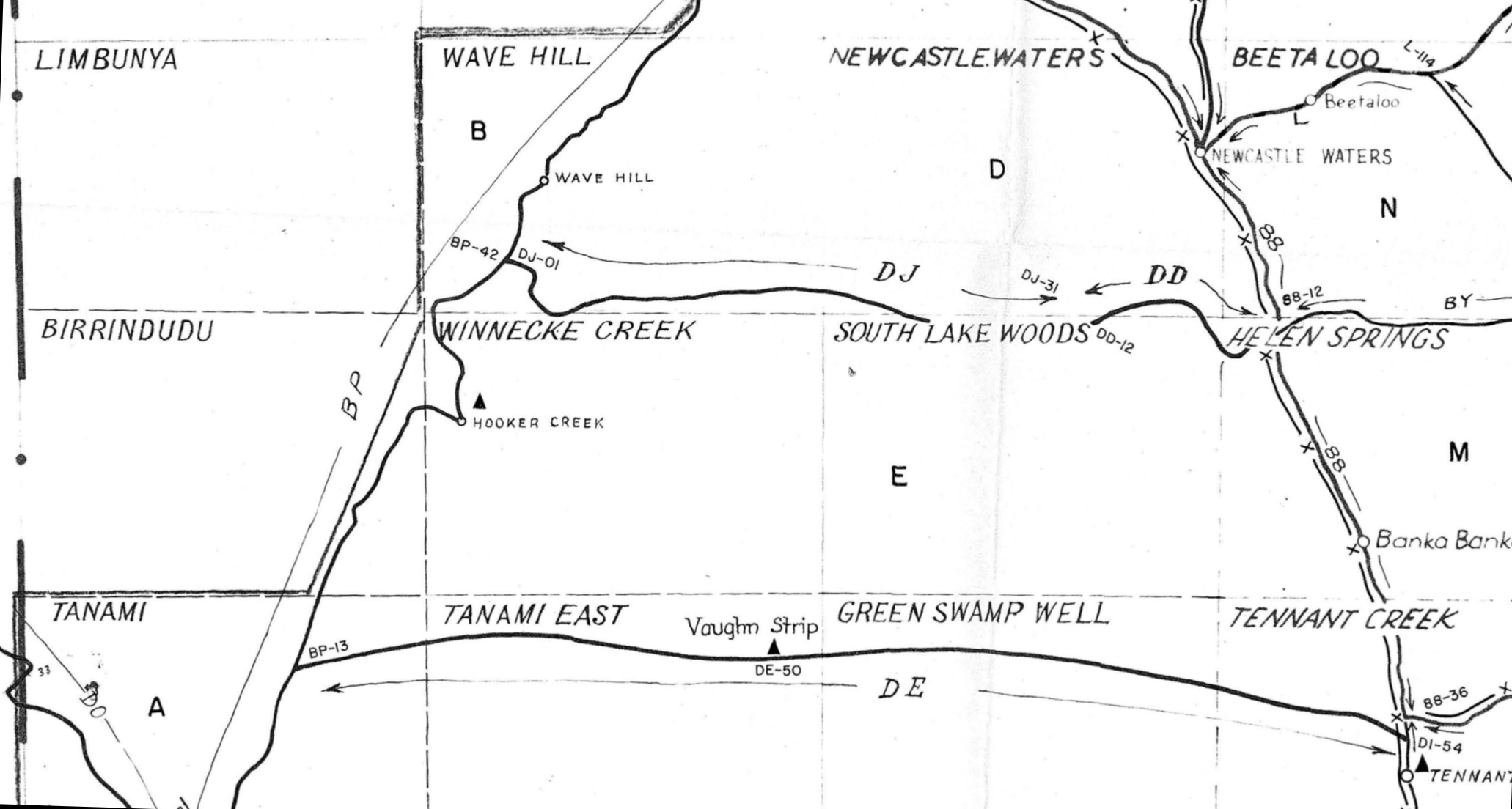
excerpt from 'GRAVITY AND ELEVATION CONTROL 1965
HELICOPTER GRAVITY SURVEY, QLD-NT' E53/B2-26-1 (Flavelle 1965)
References
Division of National Mapping. Permanent bench mark (PBM) records. NMVG
292, NMVG 391–400, NMVG 416–421, NMVG 424 (copies supplied
1/6/1984); NMVG 422 and 425 (copies supplied 20/12/1990)
Granger, Harry W. 1972. The Australian height datum. The Australian
Surveyor 24.4(December),228-237. https://doi.org/10.1080/00050326.1972.10440633
* "to provide a general description of the Australian levelling network
and its adjustment. A more detailed description is given in The adjustment of the Australian levelling survey 1970–1971,
Technical Report 12, published by the Division of National Mapping" by
Adrian Roelse, HW Granger, JW Graham) 2nd edition, 1975 http://www.xnatmap.org/report_tdnm/ahd12.pdf
Meeting with Alan Deck, Barry Sloane, and others, Auslig (N1 Ga, Unit
3, Cameron
Offices, Belconnen ACT), November and December 1990.
Colour slides by Alan Deck; copies of 6 supplied 14/2/1991.
Papers of Anthony Gerald Bomford, 1927-2003 [manuscript]. National Library of Australia Special Collections https://nla.gov.au/nla.cat-vn2514637
Advice from Laurie McLean, July 2021.
Karlantijpa history page
Karlantijpa
home
page
© 2021
David
Nash
Created 15 July 2021
Last changed 24 July 2021
URL http://www.anu.edu.au/linguistics/nash/kt/1972-levelling-survey.html