Norman Vaughan and Carlos de Lemos of the Survey Branch of the
Commonwealth Department of the Interior ran third order levels,
presumably under contract to the BMR. The
purpose was surface control for a gravity
survey carried out the following year, in the context of
Commonwealth funding for oil exploration.
Oil search
Geophysical BranchParty/Project: Dept of Interior Levelling NT; project file 62/634
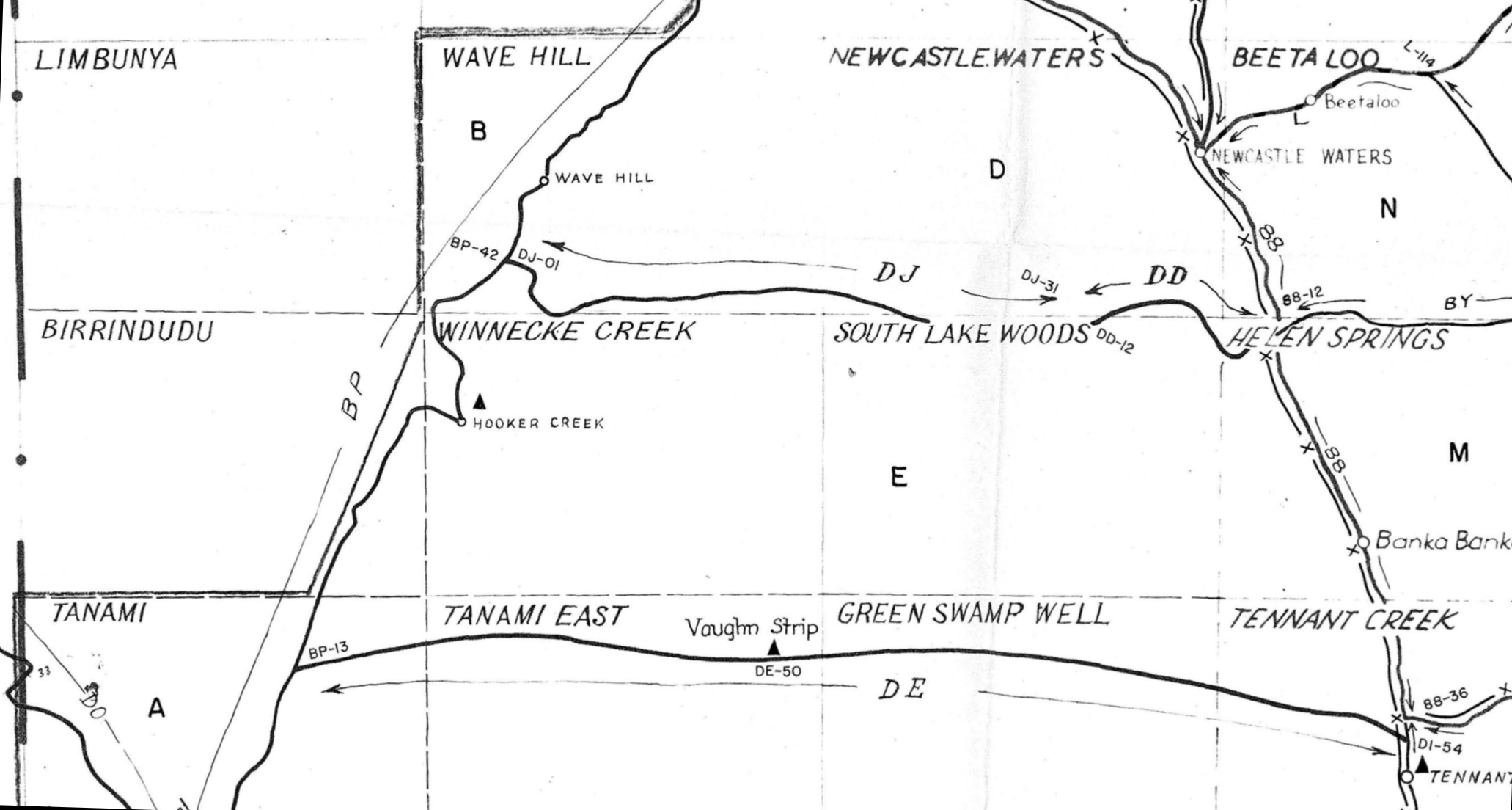
Nature of Work: Georgina Basin and Wiso Plateau. Levelling required for 1965 helicopter gravity survey. Victoria River Downs (part), Daly Waters, Tanumbirini, Bauhinia Downs, Robinson River (pt), Normanton (pt), Westmoreland (pt), Calvert Hills, Wallhallow, Beetaloo, Newcastle Waters, Wave Hill, Birrindudu (pt), Winnecke Creek, South Lake Woods, Helen Springs, Brunette Downs, Mt. Drummond, Lawn Hill, Donors Hill, Croydon (pt), Millungera (pt), Julia Creek (pt), Dobbyn, Camooweal, Ranken, Alroy, Tennant Creek, Green Swamp Well, Tanami East, Tanami (pt), The Granites (pt), Mt. Solitaire, Lander River, Bonney.Well, Frew River, Avon Downs, Mt. Isa, Cloncurry, Duchess (pt), Urandagi, Sandover River (pt), Elkedra (pt), Barrow Creek, Mt. Peake, Napperby 1:250,000 Sheet areas.
Approx timetable: April-November 1964
Staff: 7 surveyors (plus non-professional staff)
Remarks: About 30 of these sheets will be covered by contract helicopter gravity in 1965; remainder in 1966.
(BMR 1964:6)
series station date
numbers
----------------------------------
DJ 01-31 Jul Aug 64
DD 01-12 Jun Jul Aug 64
DE 03-59 Jun Jul Aug 64
The route of the DJ and DD series (between Powell Creek and Wave Hill)
is roughly along O'Brien's 1961 route. I do not know specifically
of anyone subsequently following this route on the ground.
The DE series (between Tennant Creek and Supplejack) is along roughly
the same route as Whitlock's 1941 track.
Signs of Whitlock's track is explicitly referred to in the descriptions
of various nench mark stations: see the table. An unspecified track is
referred to at DE22,
DE24, DE25, and DE26.
excerpt from 'GRAVITY AND ELEVATION CONTROL 1965 HELICOPTER GRAVITY SURVEY, QLD-NT' E53/B2-26-1 (Flavelle 1965)
|
Bench-Mark |
Speedo
reading miles (kms)* |
Whitlock-related
comments |
|
DE-18 |
82.2
(132.3) |
|
|
|
86.3
(138.9) |
Whitlock’s
1941 track follow west down hill |
|
DE-19 |
86.5
(139.3) |
North of
Whitlock’s track |
|
|
90.2
(145.2) |
Whitlock’s
track across ironstone ridge |
|
DE-20 |
91.9
(148.0) |
North of
Whitlock’s track (faint) |
|
DE-21 |
96.4
(155.2) |
North of
Whitlock’s track on low ironstone rise |
|
|
100.8
(162.3) |
Follow
well defined tracks to north-west |
|
DE-24 |
113.7
(183.1) |
Follow
tracks to right |
|
DE-26 |
125.1
(201.4) |
South of
tracks |
|
|
126.7
(203.9) |
Turn left
off main tracks |
|
DE-40 |
194.1
(312.5) |
0.2 miles
south of Whitlock’s tracks |
*Speedo readings indicate the distance from the traverse start point on the Stuart Highway.
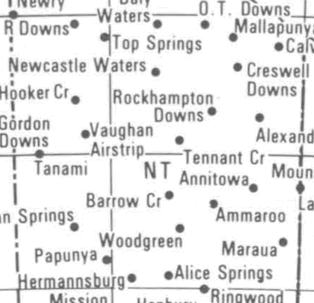
The party marked an airstrip, called Vaughan Airstrip or Vaughan
Strip, on the south of DE50. It was used for access later in 1964 as an
Isogal Secondary Station at the base gravity station established nearby
at 19°10.6'S 130°49.6'E, BMR station number 6491.9056, International
Gravity Commission numbers (IGC)
number 38390, IGC Letter J (van Son 1969,
Barlow 1970, Wellman et al 1985).
In 1967 Some of the tracks and bench marks of the DD and DJ series were used to place aerodist stations NM/G/201 and NM/G/202 — see 1967–71 National Mapping Aerodist program,
The DE series of bench marks are marked on the map in McLean 2020 [2015], and the track along them (with some spot heights) is shown on the preliminary geology maps appended to Milligan et al (1966).
Most of the eastern part of the DE route was used subsequently. In
1965 the BMR used the eastern part for access in the Wiso Basin survey.
In 1968 the estern part was used to establish dumps of helicopter
fuel for NatMap operations.
A 1972 levelling survey
used the eastern part; see also for the basic reference on the establishment of the Australian Height Datum.
The investigation of Goddard's Prospect used at least the middle part of the route, first by prospector James Weir then in
August 1974 the eastern two-thirds was graded (details here).
The part as far west as DE30 was followed by the Army in
May 1983, and then graded again in September 1983 by the Lajamanu
Council, as part of the Duck Pond-Warrego track, used over the
subsequent decade or more. The tracks between DE30 to DE39 were
followed by an RAOU survey in
1983, and here and there since 1987 in travels guided by senior
Warlpiri people.
© 2021 David Nash
Created 27 June 2021