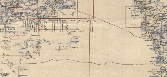
excerpt from 1945 NT Pastoral Map
Whitlock's 1941 and 1942 traverses to the west of what became the Stuart Highway are part shown by manuscript additions to Army 8 mile to an inch maps CP4619 and CP4620 (only two of three parts extant, of which I have a copy thanks to Vern O'Brien). The tracks were shown on the 1945 and 1956 NT Pastoral Maps, and on 1:1 000 000 aeronautical charts published in 1950, 1952 and 1953, but presumably became overgrown and were not shown on later editions. Curiously the tracks are also shown on a 1953 Northern Territory road map.
One man who worked for Whitlock on one of the tracks was
Frank Glastonbury (1915–84), who I talked to in Alice Springs around
1980.
From him I gathered
that the tracks were completed under arduous conditions, and despite
many
breakdowns in the equipment. (Glastonbury enlisted in the Australian
Army on 19 April 1942 at Alice Springs, so his experience was likely of
the 1941 construction of the southern track.)
The northern track, linking Muckaty and Wave Hill, is mentioned in
two
letters in files in Australian Archives (NT Branch):
letter from Administrator to AS Bingle, 21/12/1942
letter from AS Bingle to Administrator, 2/1/1943
(Alison Seymour Bingle (1895–1971) was Manager of Vesteys; the general
background
of Vesteys work with the Army, but not these tracks, is mentioned in
his
1986 memoirs.)
In 1947 an eastern part of the track was the location where tow
Aboriginal women perished, and then located by police from Newcastle
Waters:
7-5-47: ‘Const’s Bowie & Ryall at stn. Mrs Ulyatt phoned at 11.30 am and reported two lubras bush for 2 weeks whilst travelling from Helen springs to Muckadee. Tracks last seen going into waterless country and both females believed to have perished.‘
10-5-47: ‘Tracker Tommy located bodies late in evening about ¼ mile apart. Both appear to have died of thirst. Bodies found approx 24 to 30 miles west of Muckadee. Nearest water about 8 miles away. Camped at Labadah W-H.’ [Newcastle Waters police journal, NT Archives F493]
A cattle pad said to be on the eastern end of the track west from Muckaty was pointed out to us on 14 October 1980 when travelling about a mile west of Muckaty homestead.
In 1982 an enamelled metal 'Kodak Film' sign was encountered just to
the east of the summit of the Renehan Ridges. A possible source is
Whitlock's party.
On one trip Mrs. Whitlock, in a convoy of slow-moving trucks and tractors, went through sand and spinifex country where water was not known for 300 miles. She made camp twice a day, cooked for six men, and rode on a tractor. Her seat was a bag of potatoes. She wore flannel shorts and khaki shirt. (Dawes 1942)
The eastern end of the track west from Three Ways past Wilson Creek (to Gordon Downs) was a landmark for the forced landing of a B25 D-10 'Mitchell' bomber on 25/1/1945, and allowed the retrieval of the crew and cargo. (That plane was not recovered until June 1974 and is now displayed at the Darwin Aviation Museum).
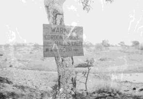 |
| Sign near eastern end of southern track, near
Alluvial area apparently photographed in 1948 by David R. Hocking from page 20 of http://xnatmap.org/adnm/ops/prog/astro_new.pdf |
Eric Olsen took a colour transparency in 1959 showing a sign which marked the eastern end of the track near Alluvial Bore (north of Warrego); the sign was then lying on the ground and read something like "Gordon Downs 300 miles. No water". According to the Rev. Arch Grant [letter of 7/3/92] there once was a similar sign he says near Attack Creek. (This may have been near Morphett Creek where the Army camp was, and from where station tracks would link to the Whitlock track to Wave Hill.)
 |
| Sign near eastern end of southern track, near
Alluvial area, photographed (lying on ground) by Eric Olsen, 1959 |
In May 1964 Max Cartwright (1995:66-67) came in a Landrover from
Duck Pond and encountered the southern track perhaps 40km west of
Alluvial. A few days later theLandrover and Bedford truck followed the
track west from Alluvial, but turned back. Then in July 1964 with five
Aboriginal men Cartwright (1995:68-69) drove from Tennant Ck to Hooker
Ck.
In mid-1964 the surveyors Vaughan and de Lemos recorded signs of what they had been told was Whitlock's track on gravelly rises between Alluvial and Wilson Creek: at bench mark DE19 (86.5 miles west of the Tennant Creek Telegraph Station), at 90.2 miles west, faint traces at bench mark DE20 (91.9 miles west), at bench mark DE21 (96.4 miles west), and at bench mark DE40 (194.1 miles west) [BMR Gravity Traverse Description, Traverse DE, Jun-Aug 1964, pp.36,38].
"Grader Jack made a track from Tennants Creek to Gordon Downs. That was during the war" (Stan Jones, interviewed at Katherine by Darrell Lewis, 23-24th August 2000).
I would like to hear from anyone who has more information about
these
two wartime tracks.
Cartwright, Max. [1995]. Missionaries, Aborigines & Welfare Settlement days in the Northern Territory. [Alice Springs, N.T.]: Max Cartwright.
Dawes,
Allan. 1942. Outback woman is pioneer. Adelaide News 15
July 1942, p.5 http://nla.gov.au/nla.news-article128364943
—. Woman is outback pioneer. The Daily News (Perth) 15 July
1942, p.4 http://nla.gov.au/nla.news-article78281025
H.E.C. Robinson Pty Ltd. 1945. Map of Northern Territory showing Pastoral Stations &c. 30.6.1945
https://www.reddit.com/r/AussieMaps/comments/g7k1gp/1945_map_of_the_northern_territory_showing/
H.E.C. Robinson Pty Ltd. 1953. Northern Territory road map. http://nla.gov.au/nla.obj-234121977
Liddle, Robyn. 1990. Historical survey of European settlement on the western Barkly Tableland for the National Trust of Australia (Northern Territory). Funded by the National Estate Grant Program. June 1990. xiii+245+[2]pp.
McLean, Laurie. 2021. Wilfred Hercy Dominick (Jerry) Whitlock (1898-1978). http://www.xnatmap.org/adnm/people/aabout/Whitlock/Whitlock%20WHD.htm
Highway Surveyor dies at age 80. Centralian Advocate 1 June, 1978.
Wilfred Hercy WHITLOCK. 1 page PDF http://whitlockfamilyassociation.com.s3.amazonaws.com/sources/miscellaneous/X3625.pdf
CRS F1 Item 1942/112 Stockroutes & Bores, 321 folios
CRS F1 Item 1943/10A Stockroutes and Bores General File, 164 folios:letter 2 Jan 1943 AIA Pty Ltd, Sydney (ASB/NMG) to Administrator, Alice Springs
'SUGGESTED ALTERATION ROAD STOCK ROUTE ALICE SPRINGS'
CRS F1 Item 51/489
Thanks to Trevor Whitlock
for
family information, to Vern O'Brien, and to Laurie McLean.
© 1992 2003 2020 David Nash
Created 10 January 2005