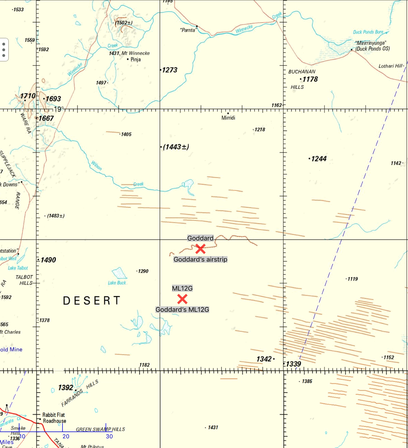
ML12G 19° 43' S 130° 35' E; airstrip 19° 31'.5 S 130° 40' E
Prospector Jim Weir drew the attention of Geopeko employees at
Tennant Creek to a copper prospect, and made an option agreement of 17 December 1973 with
Peko Mines N/L. He had an exploration licence No. 632 (granted 10
January 1973) containing
Mineral Lease No. 12G (granted 20 December 1973). (Aboriginal
Land Commissioner 1979:§§333–7).
Weir had an old grey LandRover utility with which he made lone prospecting trips, and at times recruited others to accompany him. In his travels Weir used at least some of the existing tracks along the 1964 DE series of bench marks as also used by others especially the 1966 BMR scouthole drilling, and the September 1972 levelling survey.
several reconnaissance trips using a light aircraft were flown to determine the access to the area following an exceptional wetThat vehicle was Peter Kitto's; the other was Michael Love's (p.c. Brian Williams). This is presumably the trip Weir made east of The Granites with two geologists, on which one of their vehicles was destroyed by fire. Roger Styles (DAA?, Yuendumu) and Bob OKeeffe (OIC Yuendumu Police station) guided by †Ted Egan Jangala, alerted by the Mines Dept, went to Weir's aid (via The Granites and Mt Theo). (p.c. Roger Styles)
season. A field party attempted to reach the area in June, 1974 but were forced to return when one of the vehicles was destroyed by fire. (Kitto 1975:2)
An access track was graded from the Wiso Bore to the northern boundary of the Exploration Licence in August, 1974. A l000m airstrip was constructed near the northern boundary of the Exploration Licence to service exploration parties in the area. (Kitto 1975:2)Bromage Earthmovers of Tennant Creek, graded the access track and airstrip under contract to Geopeko/ The eastern two-thirds of the route followed existing tracks along the 1964 DE series of bench marks. The east-west 1000m airstrip was aksi named Goddard's. The track and airstrip are shown on the Tanami East geology map, 1st edition. After Kitto and Le Messurier's reports the prospect was not further developed.
Weir later applied for exploration licence 1080 (applied 15.11.1974), and mineral leases Nos 13-21G (29 November 1976), which were not proceeded with.
Tennant Creek Gold Ltd's subsidiary TNG Gold Pty Ltd applied for EL 24260 'Tanami East' on 15
April 2004:
Tanami East, also known as Goddard’s Prospect, hosts significant malachite mineralisation outcropping over a strike length of 1,200 metres. Numerous values over 1% Cu and 100 ppb Au were obtained from rock chip samples carried out during the 1970s and the area is considered to have exploration potential for copper-gold deposits. (Tennant Creek Gold Ltd 2007)
Weak Copper Oxide mineralisation associated with veins hosted in a dolomite unit was discovered in the mid-1970s by Peko Mines Limited which undertook aerial geophysical surveys, rock chip sampling and general geological reconnaissance.See also Western Desert Resources Limited (2012:30).
The Goddards licence falls within a Heads of Agreement with WDR Resources (WDR) whereby WDR can earn interest in the project. WDR has currently not earned an interest in the project. (Tennant Creek Gold Ltd 2016:44, §11)
Further north, around Pussycat (No. 14) bore near the western end of
the Murranji Stock Route, Weir later held exploration licence No. 1769
in common with Harold Brennan. It expired on 19 July 1979. (Aboriginal
Land Commissioner 1980:§§107–8)
EL3506 in the Mt. Boothby area of the Napperby 1:250 000 sheet, was granted to James Weir on 5 March 1983. (Weir 1983)
© 2021 David Nash
Created 29 August 2021